
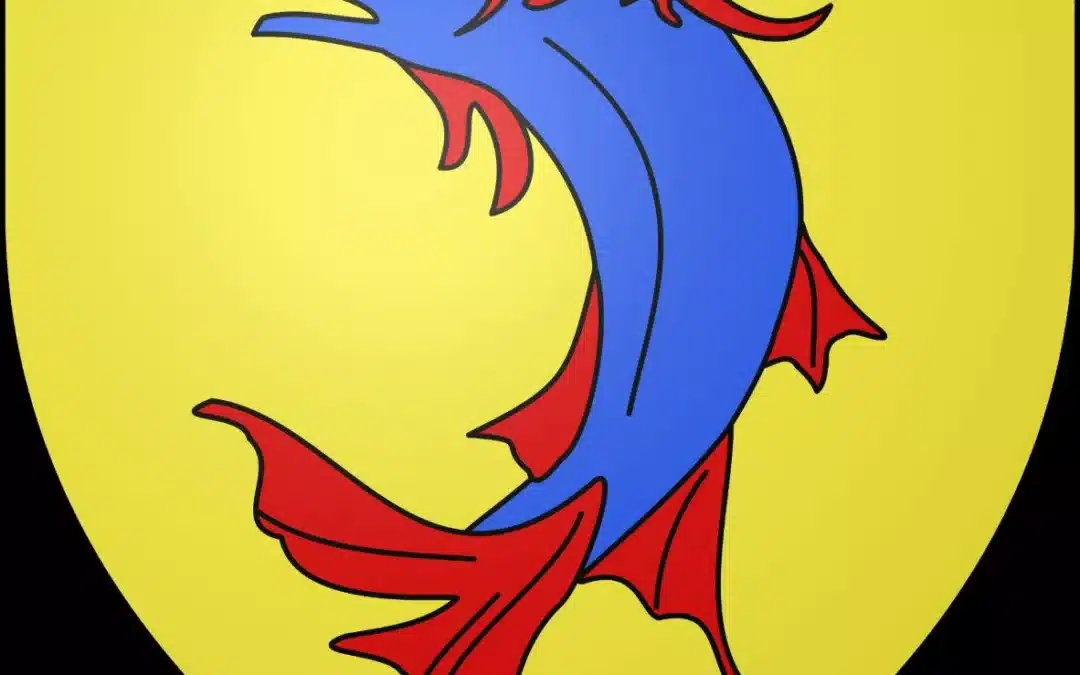
No, there are no dolphins in the Dauphiné.
At least, not the ones we're thinking of.
Yet, a simple stroll through Grenoble is enough to encounter them. When local flags adorn the city on public buildings or during festivities, two dolphins appear on the Dauphiné flag and one on the Isère flag. They are found on facades, monuments, and ancient coats of arms. More broadly, the word itself seems to be everywhere: Université Grenoble Alpes, formerly Université du Dauphiné, Dauphiné Libéré, Dauphiné Ski Alpin, roads and establishments bearing the name of DauphinéSeveral hundred kilometers from the sea, this marine animal has paradoxically become one of the most familiar symbols of the French Alps.
And then there's the territory.
The Dauphiné no longer appears on any French administrative map. It's impossible to find a region or department bearing that name. Yet, ask where Grenoble is: you'll readily be told it's the capital of the Dauphiné. In Valence, in the Vercors, around Gap, in Briançon, or in the Queyras, the word also continues to evoke a shared historical identity, even if it's felt very differently in different areas today.
Because the Dauphiné was immense.
From the plains of the Rhône to the glaciers of the Écrins, from the almost Lyonnais lands of northern Isère to the first Provençal landscapes of the Drôme, it united worlds that our current administrative divisions have separated. It looked towards Lyon and Provence, but also towards the Savoie, long a neighboring and rival state. In its high valleys, the communities of Escartons maintained relations on both sides of the Alps, in territories now shared between France and Italy.
And for centuries, the border of France was not located on the Alpine ridges that we know today.
It sometimes passed within a few dozen kilometers of Grenoble.
Grenoble was thus the capital of an Alpine principality, the Dauphiné, which disputed territories with Savoy, where a lord adopted a dolphin as an emblem and where, in 1349, an entire province entered into the French whole under an astonishing condition: The heir to the throne of France will now bear the title of Dauphin.
That is why, for several centuries, the future kings of France would be dauphins.
And that's why there are so many dolphins in the Dauphiné.
What is the Dauphiné region today?
Let's start with what it no longer is: The Dauphiné is not currently any administrative entity.
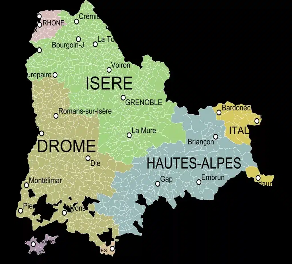
The French Revolution abolished the province in 1790, and its territory primarily gave rise to the departments of Isère, Drôme and Hautes-AlpesThis correspondence is strong enough that these three departments are often used to represent the historical Dauphiné, but it is not entirely accurate: the borders of the former province have evolved and do not coincide everywhere with the contemporary departmental boundaries. Moreover, traces of the Dauphiné can be found in certain valleys of the neighboring Italian region of Piedmont.
Administrative geography then further separated these territories.
Isère and Drôme now belong to Auvergne-Rhône-AlpesThe Hautes-Alpes belong to Provence-Alpes-Côte d'Azur.
So here is a former province now divided between two regions.
And this separation partly explains why the Dauphiné identity seems less immediately perceptible today than the Savoyard identity.
However, the territory remains logical within its geographical boundaries.
To the west, the Rhône forms a long natural boundary. Vienna, Valencia and the plains surrounding them belong to a Dauphiné of hills, crops and major transport routes.
Further east, the Prealps emerge: Chartreuse, Vercors, DévoluyBetween them lie valleys like the Grésivaudan, a veritable corridor leading from Grenoble to the Alps.
Then the mountain takes up all the space.
The Oisans region is nestled between peaks over 3,000 meters high. The Écrins massif boasts glaciers and towering summits. Further south, Gap already offers views towards the Southern Alps, while Briançon, the Queyras, and the high valleys look as much towards Piedmont as towards the French plains.
Between Vienne and the Montgenèvre pass, between the lands of Bas-Dauphiné and the peaks of the Écrins, you also change countries.
And yet, they all belonged to the Dauphiné.
Why is the Dauphiné region called Dauphiné?
The story begins with an animal.
Or rather, with a nickname that became a title.
In the Middle Ages, the powerful counts of Albon gradually controlled territories around Grenoble and in the Alps. In the 12th century, Guigues IV of Albon bears the nickname of Dolphin and uses the dolphin in its emblem. The term is passed on to his successors and eventually becomes a title.
This title of "dolphin" It therefore appears in the 12th century with Guigues IV of Albon, referred to in the texts as Guigo DelphinusThe exact origin of this name remains debated: it could be a first name or family nickname (all the Counts of Albon bear this second name, masculine Delphine), or perhaps it is linked to his mother's Mediterranean roots in reference to the Mediterranean totem animal, Mathilde, or perhaps to a more legendary origin defining knights as dolphins.
Gradually, this nickname became hereditary among the Counts of Albon, who thus took the name of Viennese dolphins, then designates their territory: the Dauphiné de Viennois, or more simply, the Dauphiné.
This origin explains a frequent confusion. The word "dauphin" did not originally refer to the heir of the King of France.
It's exactly the opposite.
The title borne by the heir of France comes from the Dauphiné.
When the territory was ceded to the Kingdom of France in the 14th century, one of the agreements stipulated that it be granted to the heir to the throne. The title of Dauphin then gradually evolved into the one we know in French history.
But before getting to that point, the Dauphiné region had to be built.
Before the Dauphiné, between the Rhône and the Alps
The territory obviously has a much older history.
In Antiquity, its northern part largely belonged to the world of Allobroges, while other peoples occupied the more southerly and alpine territories. After the Roman conquest, Vienna becomes one of the major urban centers of Gaul.
The city then possessed an importance that its current size does not always suggest.
The Rhône River already constituted a major thoroughfare, while the Alpine valleys provided access to Italy via several passes. Further south, the territories around Gap and the high valleys were also integrated into the Roman networks crossing the Alps.
After the fall of the Western Roman Empire, the Burgundian and Frankish kingdoms succeeded one another, followed by entities stemming from the Carolingian Empire. During the Middle Ages, political authority fragmented. Bishops, lords, and powerful aristocratic families shared control of the territory. Among them emerge the Counts of Albon.
How the Counts of Albon built the Dauphiné
The Dauphiné was not born all at once but gradually formed around the possessions of the counts of Albonwhose authority was established from the 11th century onwards.
Their presence is particularly strong around the Grésivaudan and Grenoble, but their territories are gradually extending towards the Alpine valleys.
This geography is essential. Indeed, possessing an Alpine valley means controlling farmland and communities, but also trade routes, mountain passes, and tollbooths. The mountains are traversed by merchants, pilgrims, soldiers, and travelers. The Dauphiné thus developed in a region that looked simultaneously towards the Rhône and towards Italy.
But another power is pursuing exactly the same strategy on the other side of its borders: the House of Savoy.
And for several centuries, the history of the two territories would be intimately linked.
Dauphiné and Savoy: neighbors, rivals and enemies
Today, traveling from Grenoble to Chambéry takes less than an hour.
The geographical continuity is such that one could almost forget that a major political border long separated the two cities.
Dauphiné and Savoy are two neighboring principalities that are expanding. Both seek to control the valleys, passes and territories located between the Rhône and the Alps.
The problem is that their possessions are long nested.
The medieval border does not resemble a regular line drawn on a contemporary map. Enclaves, lordships, and feudal rights create a complex geography where Dauphiné possessions can be found in the immediate vicinity of Savoyard territories.
Conflicts are therefore frequent.
The Grésivaudan Valley, a strategic corridor between two powers
The valley of the GrésivaudanThe area between Grenoble and the Combe de Savoie has particular importance.
Wide, fertile and relatively easy to traverse, it constitutes one of the main routes allowing access to the Alps.
North of Grenoble, controlling crossings therefore becomes essential.
Chartreuse, the Isère valley, Guiers and the territories of present-day northern Isère constituted for centuries areas of confrontation between Dauphinois and Savoyards.
This history explains the presence of numerous fortifications. Castles and strongholds were not simply built to monitor populations: they controlled a shifting border between two states.
1282: the border gradually takes shape
From the late 13th and early 14th centuries, several agreements and conflicts began to clarify the respective possessions.
But the decisive episode occurs in 1355, a few years after the Dauphiné region joined the French whole.
Le Treaty of Paris An important territorial exchange took place between King John II of France and Count Amadeus VI of Savoy. The border between Dauphiné and Savoy became more clearly defined, particularly around the Rhône and Guiers rivers.
Political geography then begins to resemble more closely that which would persist until the 19th century.
And this produces a situation that is often forgotten today: For several centuries, Savoy was a foreign country at the gates of the French Dauphiné. It will be necessary to wait 1860 so that this border would disappear with the annexation of Savoy to France.
1349: How did the Dauphiné become French?
The major turning point in the history of the Dauphiné region occurred in the 14th century.
The last independent dolphin, Humbert IIHe is an ambitious figure. He maintains a prestigious court, creates a Dauphiné Council in Grenoble and founds a university in 1339. He also participates in a crusade in the East.
But his ambitions came at a high price. A very high price. Without a direct heir and facing significant financial difficulties, Humbert II sought to relinquish his principality. After several negotiations, the Dauphiné was finally transferred to 1349 to the grandson of King Philip VI of France, the future Charles V.
We traditionally speak of the "Dauphiné transport"The word is important because, in the legal mindset of the time, it was not a simple conquest. The Dauphiné entered the French sphere of influence while retaining its own particularities, institutions, and privileges, which the monarchy pledged to respect. The territory was now closely linked to France, but it retained its specific political identity.
Why does the heir to the King of France become the "Dauphin"?
This is one of the most surprising consequences of the 1349 transport: the title of Dolphin is associated with the heir to the French crown.
The first French prince to wear it is the future Charles VFor centuries, the eldest son of the king, destined to succeed him, was called the "Dauphin of France." Louis XI was Dauphin. The son of Louis XIV was the Grand Dauphin. The son of Louis XVI was also Dauphin.
The title that we spontaneously associate with the French monarchy today is therefore directly derived from this ancient Alpine principality. Without the Dauphiné, there would never have been a "Dauphin of France".
Nor all the uses that follow from it to designate a successor or the second-place finisher in a competition…
The French Dauphiné region retained its distinctive characteristics for a long time.
Joining France did not immediately mean the disappearance of Dauphiné institutions. And this is essential for understanding the province's history.
The Dauphiné region notably retains its privileges and its own institutions. Dauphiné Council created by Humbert II, it evolved and became in the 15th century the Parliament of Dauphiné, established in Grenoble. The city thus reinforced its status as provincial capital. Magistrates, jurists, royal officers, and prominent families gave Grenoble a political importance that far exceeded its size. But over the centuries, the French monarchy became increasingly centralized. As elsewhere in the kingdom, provincial autonomy gradually clashed with the development of the royal administration.
This tension between the old liberties of the Dauphiné and the central power will reappear with extraordinary force in the eve of the French Revolution.
Before that, in the highest valleys, an original experience deserves a few moments' pause.
The Escartons, an astonishing organization of the high valleys
In the BrianconnaisThe constraints of the mountains have long fostered powerful forms of community organization.
En 1343Just a few years before the Dauphiné was transferred to France, Humbert II confirmed and extended, through a major charter, the privileges of communities grouped together in five Escartons: Briançon, Queyras, Oulx, Pragela and Château-Dauphin.
In exchange for a substantial sum paid to the Dauphin, these communities obtained or consolidated significant freedoms regarding taxation, local administration, and collective management. However, this did not constitute a small, independent republic in the heart of the Alps, a seductive but historically misleading image. The Escartons remained subject to the Dauphin and then, after 1349, to the French sovereign. They nevertheless possessed a local autonomy remarkable for its time.
Their geography is even more interesting.
The communities are located on both sides of the Alpine chainseparated by the border that runs through the Montgenèvre pass. Briançon and the Queyras are now French; Oulx, Pragelato, and Château-Dauphin are now in Italy. Piedmont.
For medieval inhabitants, the mountain ridge was therefore not necessarily a border. Mountain passes connected communities. People, livestock, goods, and information circulated from one valley to another. Shared resources, particularly pastures, forests, and canals, also necessitated elaborate forms of collective management.
This organization survived for several centuries before European political transformations divided its territory in two. You will find the details in an article dedicated to Escartons and their territorybecause their history alone allows us to look at the entire Franco-Italian border in a different light.

1713: when the border between Dauphiné and Savoy crossed the Alps
Le Treaty of Utrecht of 1713 constitutes another fundamental turning point.
The War of the Spanish Succession redrew part of the European map. In the Alps, France and the House of Savoy engaged in significant territorial exchanges. The rationale behind these exchanges was to align the border more closely with the watershed. A portion of the former Dauphiné territories located on the eastern slopes of the Alps came under Savoyard control.
The Escartons ofOulx, Pragelato and Château-Dauphin They are thus separated from Briançon and Queyras. Today, they belong to Italy.
Conversely, France receives, in particular, the Barcelonnette valley and theUbaye, which until then had been linked to the States of Savoy.
This is why the historical map of the Alps is so fascinating. A territory that is now French may once have been Savoyard. A village that is now Italian may once have belonged to the Dauphiné. And communities now separated by an international border long lived within the same political entity.
Grenoble, capital of the Dauphiné
To understand the Dauphiné, one must obviously go back to Grenoble.
The town occupies a spectacular site at the confluence of the Isère and Drac rivers, surrounded by three mountain ranges: Chartreuse, Vercors and Belledonne. This geography explains a large part of its history.
Grenoble controls the entrance to the major Alpine valleys while remaining connected to the Rhône Valley. It gradually becomes the main political and administrative center of the Dauphiné. Parliament of Dauphiné further reinforces this role.
Around him developed a society of magistrates, lawyers, and notables, giving the city a strong legal and political tradition. The old town center still bears the marks of this era: the former Parliament building, private mansions, narrow streets around Place Saint-André, and buildings that tell the story of a city that was far more political than industrial.
Because Grenoble's contemporary image as a scientific and technological city should not obscure its other identity. For several centuries, Grenoble is first and foremost a provincial capital and a border townAnd this political culture would play a surprising role in 1788.

Did the French Revolution begin in the Dauphiné?
To say that the French Revolution began in Grenoble would be an exaggeration, but it is impossible to recount the events of 1789 without looking at what happened in Dauphiné the previous year.
At the end of the 18th century, the monarchy attempted to reform its judicial institutions through strong centralization. These projects met with strong opposition from the provincial parliaments, particularly that of Grenoble. 7th June 1788The tension explodes.
The inhabitants of Grenoble opposed the departure of the magistrates and clashed with the royal troops. From the rooftops, some threw tiles at the soldiers. The event would go down in history as... Tile Day.
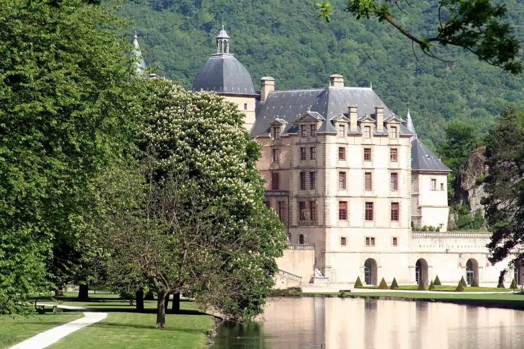
A few weeks later, the 21th July 1788 The representatives of the three estates of the Dauphiné met at Vizille, in the castle of industrialist Claude Perier.
They demanded, in particular, the convocation of the Estates-General of the kingdom and greater representation for the Third Estate. The significance of the event was considerable.
The Dauphiné thus became one of the main laboratories of the political crisis that preceded the French Revolution.
Ironically, this mobilization, intended in particular to defend certain provincial freedoms, will contribute to triggering a process that will soon abolish the old provinces!
This is at Vizille that one can visit one of the most interesting museums dedicated to the French Revolution.
1790: the Dauphiné disappears
The Revolution aimed to build a new France. The old provinces were considered to be inherited from a feudal order, with their privileges, irregular borders, and particularities.
En 1790They are replaced by the departments. The Dauphiné then ceases to exist as an administrative unit.
Most of its territory is divided between three new departments:
- Isère, around Grenoble;
- the Drômearound Valence;
- the Hautes-Alpes, around Gap.
In a few months, a centuries-old political structure disappears from official maps. But not from memories. And certainly not from the landscape.
Several Dauphinés within a single Dauphiné
Geographical diversity is probably the most striking characteristic of the former territory.
Imagine a journey from north to south.
Around Crémieu and La Tour-du-PinThe hills of the Lower Dauphiné already seem to gaze towards Lyon. The altitudes remain modest, the landscapes are agricultural, and the Alps appear in the distance.
Then comes Grenoble.
Just a few kilometers away begins the Grésivaudan, a wide valley bordered by Belledonne and Chartreuse mountains.
Then head towards theOisans and the landscape abruptly shifts into the high mountains: peaks of the Écrins, glaciers, deep valleys.
Cross the Vercors and you will discover vast limestone plateaus cut by vertiginous cliffs.
Head down towards the Drôme region and the climate changes again.
In the DioisAround Die, the light becomes southern. Further on, olive trees appear. At NyonsIt's hard not to already feel like you're in Provence.
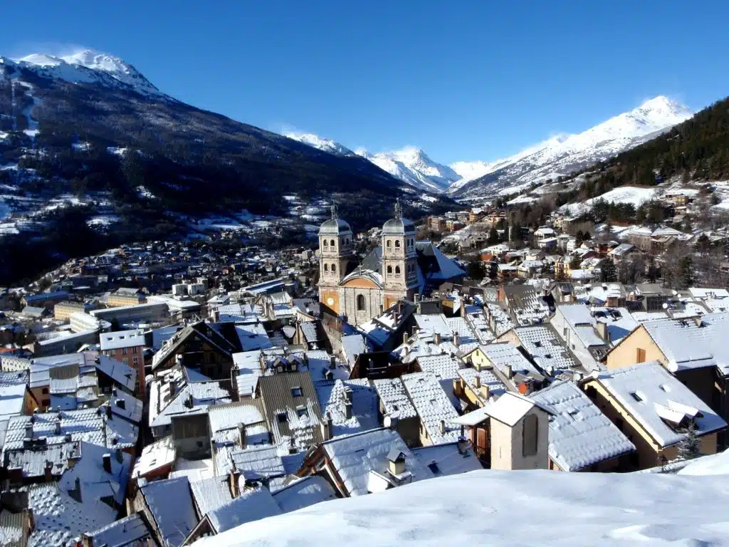
Then head back up towards Gap, Embrun, Briançon or the Queyras, the High mountains.
You find yourself in the mountains, but a different kind of mountain: drier, brighter, influenced by the Mediterranean.
The Dauphiné region is truly a succession of worlds.
Is the Dauphiné region Alpine or Provençal?
This is one of the most interesting questions when travelling through the south of the former Dauphiné.
À NyonsThe olive trees, lavender and cicadas seem to announce Provence.
In Die, the vegetation and the light already have a southern feel.
Gap is now located in an administrative region which is officially called Provence-Alpes-Côte d'Azur.
And yet, historically, these territories belong to the Dauphiné region.
The confusion arises from the fact that Cultural geography and political borders do not necessarily coincide.
Historical Provence is located further south.
But Mediterranean influences naturally flow up the valleys far beyond its ancient borders.
One can therefore be historically from the Dauphiné region and culturally very close to Provence.
This transition is particularly visible in the Drôme.
The famous expression Provencal Drome does not constitute a historical contradiction: it precisely describes this progressive shift from the Rhone and Alpine world towards the Mediterranean world.
What language was spoken in Dauphiné?
Here a fundamental difference with Savoy emerges.
There is no single traditional linguistic area covering the whole of the Dauphiné.
The territory is located at the intersection of two major Romance language groups: Franco-Provençal, today often called Arpitan, and Occitan.
In the north, the traditional dialects belong to the Franco-Provençal domain, like those of a large part of Savoy, Lyonnais, French-speaking Switzerland and the Aosta Valley.
Heading south, one gradually enters the Occitan domain.
This linguistic boundary is obviously not a perfectly clear line on the ground. Local variations, transition zones, and exchanges between valleys make the reality much more nuanced.
But it reveals something fundamental.
The Dauphiné region is located at the meeting point between Northern France, the Alpine world and the Occitan Midi.
Its cultural diversity is reflected even in the languages once spoken by its inhabitants.
The architecture also tells the story of several Dauphinés
It is impossible to define a single "Dauphiné house".
In the Lower Dauphiné, agricultural buildings respond to the hilly landscapes and locally available resources.
In the Vercors region, massive farms have to cope with harsh winters.
In Oisans, the housing is concentrated in villages clinging to the slopes.
In the Queyras, wood takes a spectacular place in some traditional houses, with their large balconies and structures adapted for storing fodder.
In the Briançonnais region, stone often dominates more and villages are concentrated to save arable land.
Further south, the roofs soften and the villages begin to take on Mediterranean accents.
As always in the Alps, Architecture primarily reflects the climate, available materials, and local economy..
What do people eat in Dauphiné?
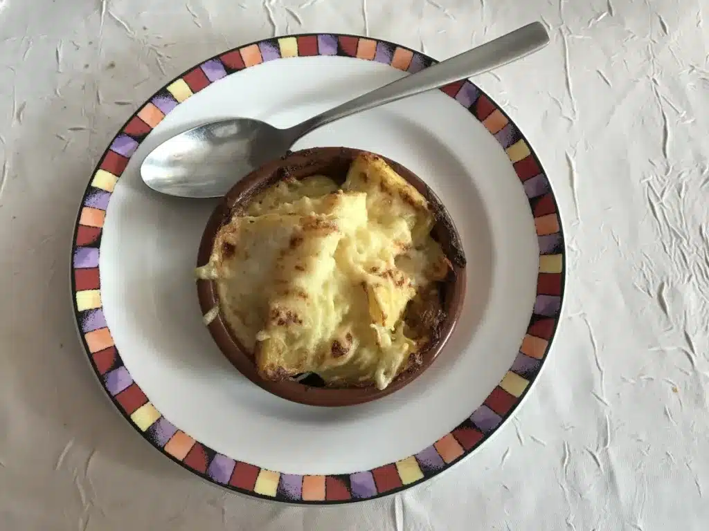
Ask this question and someone will immediately answer: the gratin dauphinois.
It has become one of the most famous dishes in French cuisine, to the point of almost making everyone forget everything else.
However, the territory boasts a remarkable gastronomic diversity.
Around Grenoble, the walnuts This has long structured certain agricultural landscapes. Saint-Marcellin belongs to the cheese heritage of the Lower Dauphiné. blue of Vercors-Sassenage tells the story of the high plateaus.
Further south appear the Dauphiné ravioli, particularly around Royans.
In the Hautes-Alpes, the tourtons, donkey ears and various mountain preparations already testify to other influences.
In the Diois region, the vine takes on considerable importance with the Clairette de Die.
Then come the wines of the Rhône Valley, the olives of Nyons and the Mediterranean products.
All you have to do is follow the recipes to travel all over the Dauphiné region from north to south.
Is the dolphin still the symbol of the Dauphiné?
More than eight centuries after Guigues IV, the animal is still there. The traditional arms of the Dauphiné depict a Azure dolphin, crested, barbed, finned, scaled and eared gules on a gold background.
Heraldic vocabulary is complex. The image, however, is immediately recognizable.
After the Dauphiné region was incorporated into France, the provincial coat of arms also combined the royal fleur-de-lis and dolphins. Even today, the emblem appears on buildings, products, associations, and numerous heritage sites.
And above all, the word Dauphiné itself never disappeared.
Does a Dauphiné identity still exist today?
Yes.
But it functions differently from Savoyard identity.
In Savoy and Haute-Savoie, Savoyard identity remains immediately identifiable. The Savoy cross is omnipresent, the name still corresponds to that of a department, and the history of the House of Savoy remains strongly associated with the territory.
The Dauphiné region has been administratively extinct for over two centuries. And above all, its former territory has been fragmented among very strong contemporary identities.
- A resident of Briançon would readily call themselves a high-alpine or a Briançonnais.
- In Nyons, the Provençal identity can be highlighted more.
- Around Grenoble, the term dauphinois remains much more prevalent.
- In the north of Isère, the influence of Lyon is significant.
This fragmentation does not mean that the Dauphiné has disappeared.
It simply shows that Historical identity has been superimposed on other affiliations..
Perhaps the best example is the name of the major regional daily newspaper, The Dauphiné Libéré, founded in 1945. Its area of distribution has long far exceeded the limits of the former province, but its name shows how the term "Dauphiné" remains capable of identifying an entire Alpine and Rhone region.
The history of the Dauphiné also forces us to look at France differently.
When it was transferred to him in 1349, the territory did not immediately disappear into the kingdom. It retained its privileges, its institutions, and its capital. It even gave the heir to France a title that he would bear for centuries.
Our contemporary borders sometimes make this geography difficult to imagine.
Yet it explains a great deal: the fortresses, the roads, the languages, the architectures and even the cultural differences that we encounter today between Grenoble, Valence, Gap and Briançon.
So, Are there dolphins in the Dauphiné region?
Yes, finally.
They can be found on old coats of arms, on building facades, and in history books. They gave their names to princes, and later to the heirs of the kings of France. But perhaps the most interesting thing is not what happened to the dauphins.
It's about discovering that the Dauphiné itself is still there, hidden beneath the administrative map of contemporary France.
Photo credits:
Dauphiné map: White goose, CC BY-SA 3.0 https://creativecommons.org/licenses/by-sa/3.0, via Wikimedia Commons // https://upload.wikimedia.org/wikipedia/commons/6/61/Carte_du_Dauphin%C3%A9.svg
Dauphiné coat of arms: Fauntleroy, CC BY-SA 3.0 https://creativecommons.org/licenses/by-sa/3.0, via Wikimedia Commons // https://upload.wikimedia.org/wikipedia/commons/2/24/Blason_Dauphins_du_Viennois.svg
Vizille Museum: Isere-culture, CC BY-SA 4.0 https://creativecommons.org/licenses/by-sa/4.0, via Wikimedia Commons // https://upload.wikimedia.org/wikipedia/commons/2/26/Domaine_de_Vizille_-_Mus%C3%A9e_de_la_R%C3%A9volution_fran%C3%A7aise.jpg
Gratin Dauphinois: Benoît Prieur, CC0, via Wikimedia Commons // https://upload.wikimedia.org/wikipedia/commons/9/9f/Gratin_Dauphinois_%C3%A0_l%27Auberge_Rouge_%28Saint-Maurice-de-Beynost%29.JPG
You might also be interested in these articles:
From the Écrins mountains to Piedmont, following in the footsteps of the Waldensians, reformers of the Alps
Trace the journey of the Waldensians, a reformed religious community, through the Alps between Hautes-Alpes and Piedmont, between history, heritage and unmissable landscapes.

Escartons: a cross-border territory in the Alps between Dauphiné and Piedmont
What is the territory of the Escartons? During a visit to the Piedmontese Alps, the Queyras or the Briançonnais, discover the amazing history of these autonomous alpine communities.
Why are there Occitan Valleys in Piedmont, Italy?
Discover the Occitan Valleys in the Piedmont Alps. Where culture transcends time and borders, enriching your travels or hikes.
What to see in the 12 Occitan Valleys of the Italian Alps?
Discover the 12 Occitan valleys of Piedmont: villages, landscapes, heritage and traditions of an Alpine culture that transcends borders.
Around Monte Rosa, the land of the Walser
Discover the history and Walser heritage in the valleys around Monte Rosa. Between Valais, Aosta Valley and Piedmont, a common thread unites these highlands at the foot of the glaciers.
In Barcelonnette, an incredible story connects the Alps to Mexico
Discover Barcelonnette, the main center of the Ubaye Valley. Between mountains, history, architecture and Mexican festivals, it's impossible to get bored!
What to do in Jausiers, crossroads of the Southern Alps?
Discover Jausiers, crossroads of the Southern Alps, at the foot of the great passes and with an amazing history.

What to do at Lake Orta, a romantic gem near Lake Maggiore?
What to do at Lake Orta? Visit Orta San Giulio, San Giulio Island, Sacro Monte, Omegna, the most beautiful panoramas, hikes and access points near Lake Maggiore.

The most beautiful villages around Stresa, on the shores of Lake Maggiore
Explore the most beautiful villages around Stresa: Baveno, Belgirate, Verbania, Pallanza, Mottarone and the Borromean Islands along Lake Maggiore.

The Borromean Islands: Discover the jewels of Lake Maggiore
Visit the Borromean Islands: Isola Bella, Isola Madre and Isola dei Pescatori. History, palaces, gardens, access, tips and panoramas of Lake Maggiore.

What to do in Stresa? Discover the elegant pearl of Lake Maggiore
Discover Stresa, the most elegant resort on Lake Maggiore: stroll along the shores, Belle Époque villas, gardens, panoramas, Mottarone and the Italian dolce vita.

My articles on the heritage and history of the Alps
Find here all the articles I have written on the history of the Alps and the House of Savoy on the media “Nos Alpes”

Five regions of the French Alps to discover by train
Discover five beautiful regions of the French Alps, easily accessible by train. Hop off at your local station and enjoy the mountains!
Journey to the heart of Queyras, along the Guil
The beating heart of Queyras lies along the Guil: wild landscapes, alpine villages, Fort Queyras and hikes facing Mont Viso
Three major passes in the Southern Alps: Larche, Lombarde and Bonette
Explore this high-altitude route between Ubaye, Piedmont and Tinée: Mexican villas, sanctuaries and wild passes.
The most beautiful passes in the Alps: Col du Galibier and Col du Lautaret
From Maurienne to Briançon, cross Galibier and Lautaret between fortresses, alpine villages and sublime landscapes.
Itinerary in the Alps between France and Italy: Mont Cenis and Montgenèvre passes
Between Mont-Cenis and Montgenèvre, follow a thousand-year-old road between strategic passes, forgotten forts and Alpine towns steeped in history.

Itinerary in the Alps: from Briançon to Queyras via the Col de l'Izoard
Between Briançon and Mont-Dauphin, cross Queyras via the legendary Izoard Pass: villages, fortresses, forests and lunar landscapes
Spring Skiing: Where to Ski in April in the French Alps
Skiing in the French Alps in April is still possible. Here are the resorts where you'll experience the best spring skiing!
Montgenèvre, one of the oldest ski resorts in France
Skiing in Montgenèvre between France and Italy, under the sun of the Southern Alps. Excellent snow, TOP slopes!